County Clare
| County Clare Contae an Chláir |
||
 |
||
|---|---|---|
| Motto: Dílis d'ar nOidreacht (Irish) "True to our heritage" |
||
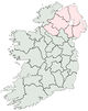
| Location | ||
|
||
| Statistics | ||
| Province: | Munster | |
| County seat: | Ennis | |
| Code: | CE | |
| Area: | 3,147 km2 (1,215 sq mi) (8th) | |
| Population (2006) | 110,810 (19th) | |
| Website: www.clarecoco.ie | ||
County Clare (Irish: Contae an Chláir) commonly referred to as simply Clare, is one of the twenty-six counties of the Republic of Ireland, and also one of the thirty-two counties of Ireland, located within the province of Munster. Clare provides a basis for local government, in the form of its own constituency within the Dáil Éireann. The county system has existed since the 16th century; as well as its governmental usage, the counties form a significant part of local identity and culture within the country. Located on the west coast of Ireland, Clare is northwest of the River Shannon covering a total area of 1,215 square miles (3,147 km²). The most populated town and county seat is Ennis.
During the Early Middle Ages the area was part of the Kingdom of Connacht ruled by the Uí Fiachrach Aidhne, until it was annexed to the Kingdom of Munster to be settled by the Dalcassians in the mid-900s. It was renamed Thomond, meaning North Munster and spawned Brian Boru during this period, perhaps the most noted High King of Ireland. From 1118 onwards the Kingdom of Thomond was in place as its own petty kingdom, ruled by the O'Brien Clan. There was some Norman influence during the 14th century due to battles with the de Clare's for control. Sovereignty of Thomond was handed over to the Tudors in 1543 and the area joined the Kingdom of Ireland as a county. After the kingdom was merged into the United Kingdom, there were wars in the 20th century which resulted in secession of the Irish Free State. The conclusion of the pro-treaty, anti-treaty Irish Civil War confirmed its status — the state became the present republic Ireland in 1937.
County Clare succeeded the district of Thomond (which was part of Connacht), and when first created it was sometimes called County Thomond. Its nickname is the Banner County, which may refer to a former local tradition of carrying banners at political meetings and public occasions.
Contents |
History
Prehistory and antiquity
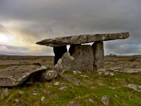
There was a Neolithic civilisation in the Clare area — the name of the peoples is unknown, but the Prehistoric peoples left evidence behind in the form of ancient dolmen; single-chamber megalithic tombs, usually consisting of three or more upright stones. Clare is one of the richest places for these tombs in Ireland, the most noted is in The Burren area, it is known as Poulnabrone dolmen which translates as the hole of sorrows.[1] The remains of the people inside the tomb have been excavated and dated to 3800 BC.[1] Ptolemy created a map of Ireland in his Geographia with information dating from 100 AD, it is the oldest written account of the island with geographical features.[2] Within his map Ptolemy names the Gaelic tribes inhabiting it and the areas in which they resided; in the area of Clare he identified a tribe known as the Gangani.[3] Historians have found the tribes on the west of Ireland hardest to identify with known peoples, however Camden and O'Conor speculated a possible connection between the Gangani and the Concani,[4][5][6] one of the eleven tribes in the confederacy of the Cantabri in the northern part of the Iberian Peninsula.[7]
Middle Ages
Early Modern
Contemporary
Governance

In the present day Clare is represented by its own parliamentary constituency in Dáil Éireann, the lower house of the Irish parliament or Oireachtas and has since 1921. Clare is currently served by four Teachtaí Dála, known in shorthand as TDs. Briefly a small area of Clare was in the Clare-Galway South constituency during the 1970s before its abolition. The second tier of local governance is represented by the town councils—Clare has four in the form of Ennis, Kilrush, Kilkee and Shannon. The constituency is historically a Fianna Fáil stronghold, which since the establishment of Irish secession has represented a centrism form of liberal conservatism in the country; Fine Gael has also had success in recent years. Prominent former TDs for Clare include Éamon de Valera who went on to become Taoiseach and President, former president Patrick Hillery and former Cabinet Minister Brendan Daly.
Earlier in its history while part of the Kingdom of Ireland, Clare had its own constituency from 1614 until 1800, sending Members of Parliament to the Irish House of Commons, which was the lower house of the Parliament of Ireland. Between the years 1725 and 1793 however, Catholics who made up the majority, were not allowed to hold office. While part of the United Kingdom of Great Britain and Ireland its constituency continued, this time sending MPs to the House of Commons of the United Kingdom. Some of the better known representatives were William Vesey-FitzGerald and Daniel O'Connell, the latter is well known for his campaign for Catholic Emancipation. During this time Ennis was represented by its own borough constituency. The Clare constituency was split up into East Clare and West Clare in 1885, this continued until Irish secession in the 1920s. Previously when Ireland was a kingdom, the monarch was represented in Clare by a High Sheriff from the 16th century onwards and its own Lord Lieutenant from the 1831; both titles are now defunct.
| Position | Current Representatives |
|---|---|
| Teachta Dála |
|
| County Council Members |
|
Geography
Landscape and rivers
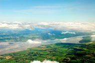
Bodies of water define much of the physical boundaries of Clare. To the southeast is the River Shannon, Ireland's longest river, and to the south is the Shannon Estuary. The border to the northeast is defined by Lough Derg which is the third largest lake on Ireland. To the west is the Atlantic Ocean.
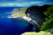
County Clare contains The Burren, a unique karst region, which contains rare flowers and fauna. At the western edge of The Burren, facing the Atlantic Ocean, are the Cliffs of Moher. The highest point in County Clare is Moylussa, 532m, in the Slieve Bernagh[8] range in the east of the county.
Climate
| Climate data for County Clare | |||||||||||||
|---|---|---|---|---|---|---|---|---|---|---|---|---|---|
| Month | Jan | Feb | Mar | Apr | May | Jun | Jul | Aug | Sep | Oct | Nov | Dec | Year |
| Source: Clare Tour[9] | |||||||||||||
County borders
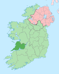
The only county which is physically connected to Clare by land is County Galway to the north. However, there are several across-water bridges which connect it eastwards County Tipperary and southwards County Limerick. Along with County Cork, County Kerry, County Waterford, County Limerick and County Tipperary, County Clare is part of Munster which is one of the four traditional provinces of Ireland.
Main towns
- Ennis / Inis
- Shannon
- Kilrush
Other small towns and villages
- Ballynacally, Ballyvaughan, Barefield, Broadford
- Carrigaholt, Carron, Clarecastle, Clonlara, Connolly, Cooraclare, Corofin, Cratloe, Creegh, Cross, Crusheen
- Doolin, Doonbeg, Doora
- Ennistymon
- Fanore, Feakle, Fenagh
- Inagh, Inch
- Kilbaha, Kilfenora, Kilkee, Killadysert, Killaloe, Killimer, Kilmaley, Kilmihil, Kilmurry McMahon, Kilnamona, Knockerra
- Lahinch, Liscannor, Lisdoonvarna, Lissycasey
- Meelick, Miltown Malbay, Mountshannon, Mullagh
- Newmarket-on-Fergus
- O'Briensbridge, Ogonnelloe
- Quilty, Quin
- Ruan
- Scariff, Sixmilebridge
- Tuamgraney, Tubber, Tulla
- Whitegate
Islands
- Aughinish
- Inishmore (or Deer) Island
- Mutton Island
- Scattery Island
Demography
| Historical populations | ||
|---|---|---|
| Year | Pop. | %± |
| 1841 | 286,394 | — |
| 1871 | 147,864 | −48.4% |
| 1901 | 112,334 | −24.0% |
| 1936 | 89,879 | −20.0% |
| 1966 | 73,597 | −18.1% |
| 1996 | 94,006 | 27.7% |
| 2006 | 110,800 | 17.9% |
| Source: Clare Library[10] | ||
The population of Clare accounted for 110,810 people at the most recent census in 2006.[11] The main urban areas are Ennis with a population of 24,253 and Shannon with 9,222. The demographic profile for Clare in general is fairly young: 22% are under age 14, while 12% are over 65, compared to the national average of 20% and 11%, respectively.[12] There is a slightly higher percentage of males with 50.5%, while females number 49.5%.[11]
English is the main language spoken in Clare. The vast majority of the population are native Irish people, accounting for 86%; immigration to Clare is relatively low compared to places with larger urban areas in Ireland such as Dublin for example. Most immigrants are Europeans totaling an additional 7,520; there is also a small African minority of 1,124 people while other groups are very small in number.[13]
In addition to this there is a large Clare diaspora due to vast migration during the 1800s. There are millions of people around the world who can trace their family background to Clare; these are mostly present in North America, Great Britain, Australia, South Africa, Argentina and New Zealand.[14] While this has stunted the population growth in a significant way, in the modern day it has meant that many people visit the area to trace their family roots and background.[14] Most of the names in Clare are derived from septs of the Dalcassian race of Gaels; some of the most common examples are O'Brien, MacMahon, MacNamara, Moloney, O'Grady, Hogan, Considine and Lynch.[14][15] There are also some names of assimilated Norman origin such as Burke, Dalton, Comyn and Bonfield.[16]
Religion
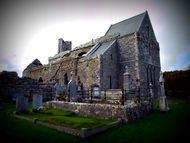
The most dominant religion in County Clare is Christianity; at least 92% of the people in the area polled as part of the Ireland Census 2006 identified as Christians.[17] There are numerous abbeys and priories in Clare; some of the ruins of these such as Scattery Island, Bishop's Island and Drumcliff Monasteries are ancient, dating back to the 6th century when Christianity was first introduced to Ireland. The former was founded by Saint Senan who was born locally near Kilrush in 488 and is counted amongst the Twelve Apostles of Ireland.[18] There are numerous other saints from Clare, such as Flannan, Mochulleus, Moula, Caimin, Maccreiche, Munchin and more.[19] In the present day the Catholic Church are in the majority with 88% of the populance declaring themselves as followers of the religion, this is slightly above the national average.[17]
Most of Clare falls under the Catholic bishopric of the Diocese of Killaloe which is part of the ecclesiastical province of Cashel and Emly.[20] The Bishop of Killaloe is seated at the St Peter and Paul Cathedral in Ennis. A small portion of the north-western part of Clare falls under the Diocese of Galway, Kilmacduagh and Kilfenora.[21] As part of the local council's architectural conservation project around eighty Christian churches are protected structures, some of the more notable structures include the ruins of Corcomroe Abbey, Quin Abbey and Dysert O Dea Monastery.[22] The largest religious minority is the Church of Ireland which is part of the Anglican Communion, with just under 2000 people[17] in Clare belonging to the institution it is covered by the Diocese of Limerick and Killaloe, one of the two cathedral's of the diocese is St Flannan's Cathedral in Killaloe.[23] Other religious communities in Clare are very small in comparison, while there is also a minority who declare no religion.[17]
Culture
Places of interest
County Clare is known for beautiful natural scenery.
- Cliffs of Moher
- Doolin
- Ballyea waterfall
- The Burren
- Spanish Point
- Scattery Island only 2 km offshore from Kilrush town.
Music
County Clare has a strong history of Traditional music. It is home of the Kilfenora Céilí Band, Stockton's Wing, Sharon Shannon, Eoin O'Neill, Eamon Cotter, Peadar O'Loughlin, Martin Hayes and legendary tin-whistler Micho Russell. Ennis in County Clare is also the birthplace of Grammy-nominated songstress Maura O'Connell whose grandmother started a fish market in the Town. The county has many traditional music festivals and one of the most well known is the Willie Clancy Summer School, which is held every July in the town of Miltown Malbay in memory of the renowned uilleann piper, Willie Clancy. Contemporary music from Co. Clare includes The Walls who hail from Ennistymon and are former members of The Stunning.
Miltown Malbay is home to Oidhreacht an Chlair, an institute for higher education in all aspects of Irish tradition, history and literature.
To get a full listing of what is on in Co. Clare in music - trad sessions, socials, gigs, festivals, children's music events and much more - check out [www.clarefocus.ie]
Sport
The Clare hurling team has one of the best records of success in the country in recent years with many cups such as the Liam McCarthy Cup having been won in 1995 and 1997 and also finalists in 2002. Clare won the Munster Final in football in 1992 beating Kerry. There is a strong Gaelic Athletic Association(GAA) presence in County Clare with the founder of the GAA, Michael Cusack, having been born in Carron which is situated in the heart of the Burren in North Clare. The sport of dog wrestling was introduced and developed in the Lahinch Road area of Clare but unfortunately never gained its potential popularity. Irish rugby internationals from Clare include Keith Wood, Anthony Foley & Marcus Horan.
One of the newer sports to take off in Clare is Aussie Rules, the county's first club the Clare Crows participate in the Aussieproperty.com Premiership in the Australian Rules Football League of Ireland. A number of crows players have represented Ireland's National Aussie Rules Team, the Irish Warriors. The Club train in Ennis and play their home matches at the North Clare Sport and amenities park in Lisdoonvarna.
Transport
Clare is served by two national primary roads—a classification referring to the major routes between major urban centres in Ireland.[24] This includes the N18 connecting Limerick to Galway, which passes through Ennis and by route of the N19—Shannon.[24] These two roads are part of the wider Western and Southern Corridor connecting many of the major settlements right across the island in these areas. There are also some significant national secondary roads—across the coast, stretching from Ballyvaughan, through Ennistymon and Kilkee, before arriving at Kilrush is the N67.[24] In addition to this the N63 connects Kilrush to Ennis, while Ennis is connected to Ennistymon via the N85.[24]
Mainland public transport is mostly limited to buses ran by Irish Government owned company Bus Éireann; there are around 25 buses running frequent routes which pass through the majority of large settlements in Clare.[25] The Ennis railway station operated by government owned Iarnród Éireann is the only functioning railway station in Clare today; it was opened on 2 July 1859.[26] By route of Limerick the trains run from Ennis to Dublin and it generally takes 3 hours to complete the journey.[27][28] There was previously a far more extensive local railway network in Clare, laid while part of the United Kingdom, the West Clare Railway was in existence from its opening in 1887 by Charles Stewart Parnell until 1961 covering much of the county.[29] It was quite inefficient however, leading Percy French to write the song Are Ye Right There Michael? about his experience. Much of it was dug up and dismantled by the Irish government from the 1950s—1970s after being deemed uneconomic, however there remains local advocacy groups who wish to conserve and restore parts of it.[30]
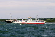
The second busiest airport in Ireland is located in Clare with the Shannon International Airport, which officially opened in 1945.[31] Along with Dublin Airport and Cork Airport it is one of the three primary airports in the country, handling 3.62 million passengers in 2007. Shannon was the first airport in Ireland to receive transatlantic flights.[31] Ryanair is the main airline handling flights with Great Britain and Continental European countries such as Spain, France, Italy and Germany as the primary destinations.[32] Much traffic from the United States is received, which Aer Lingus mostly handles; it is sometimes used as a military stopover which has caused some controversy in the country,[33] but nonetheless has generated significant revenue for the airport.[34] There are some local ferry services as much of the county is surrounded by water; there is one from Killimer to Tarbert Island in Kerry[35] and also from Doolin to the Aran Islands of Inisheer and Inishmore.[36]
Sources
Notes
- ↑ 1.0 1.1 "Neolithic Sites in Ireland". MyGuideIreland.com. http://www.myguideireland.com/neolithic-sites-in-ireland. Retrieved on 2 October 2008.
- ↑ "Ptolemy's map of Ireland: a modern decoding". InformAWorld.com. http://www.informaworld.com/smpp/content~content=a791562641~db=all~jumptype=rss. Retrieved on 2 October 2008.
- ↑ "The Arrival of the Celts". WesleyJohnston.com. http://www.wesleyjohnston.com/users/ireland/past/pre_norman_history/iron_age.html. Retrieved on 2 October 2008.
- ↑ O'Laughlin, The Families of County Clare, Ireland, 7.
- ↑ "Before there were Counties". RootsWeb.com. http://www.rootsweb.ancestry.com/~irlkik/ihm/irehstry.htm. Retrieved on 2 October 2008.
- ↑ Four Masters, "The Annals of Ireland by the Four Masters" as translated by Owen Connellan., 393.
- ↑ Anthon, A Classical Dictionary, 368.
- ↑ NB: not related to the Slieve Bearnagh mountain in County Down.
- ↑ "Climate". Clare-Tour.com. 25 December 2008. http://www.clare-tour.com/climate/.
- ↑ "Census figures 1821 - 2006 (Clare)". ClareLibrary.ie. http://www.clarelibrary.ie/eolas/coclare/history/faqs/18212006.htm. Retrieved 25 December 2008.
- ↑ 11.0 11.1 "Population of each Province, County and City, 2006". Central Statistics Office Ireland. http://www.cso.ie/statistics/popofeachprovcountycity2006.htm. Retrieved 25 December 2008.
- ↑ "Persons, males and females in each Province, County and City classified by age group, 2006". Central Statistics Office Ireland. http://beyond2020.cso.ie/Census/TableViewer/tableView.aspx?ReportId=73676. Retrieved 25 December 2008.
- ↑ "Persons, males and females usually resident in each Province and County, and present in the State on Census Night, classified by ethnic or cultural background, 2006". Central Statistics Office Ireland. http://beyond2020.cso.ie/Census/TableViewer/tableView.aspx?ReportId=5780. Retrieved 25 December 2008.
- ↑ 14.0 14.1 14.2 "Clare Diaspora". Clare Heritage & Genealogical Research Centre. http://www.clareroots.com/. Retrieved 25 December 2008.
- ↑ "Dál gCais or The Dalcassians of Thomond". DalcassianSeptembercom. http://www.dalcassiansept.com/pedigrees/dalcassian.htm. Retrieved 12 November 2008.
- ↑ "Norman and Cambro-Norman Surnames of Ireland". Family-Crests.com. http://www.family-crests.com/family-crest-coat-of-arms/last-names/norman-surnames-of-ireland.html. Retrieved 25 December 2008.
- ↑ 17.0 17.1 17.2 17.3 "Census 2006 - Volume 13 - Religion". Central Statistics Office Ireland. http://www.cso.ie/census/census2006_volume_13.htm. Retrieved 25 December 2008.
- ↑ Gratton-Flood, W.H. (March 1, 1907), "The Twelve Apostles of Erin", The Catholic Encyclopedia (New York: Robert Appleton Company) I, http://www.newadvent.org/cathen/01632a.htm, retrieved 2008-02-09
- ↑ "County Clare Folk-Tales and Myths: Early Christian Period". ClareLibrary.ie. http://www.clarelibrary.ie/eolas/coclare/folklore/folk_tales/chapter5.htm. Retrieved 25 December 2008.
- ↑ "History of the Killaloe Diocese". KillaloeDiocese.ie. http://www.killaloediocese.ie/HISTORY.htm. Retrieved 25 December 2008.
- ↑ "Diocese of Galway, Kilmacduagh and Kilfenora". GalwayDiocese.ie. http://www.galwaydiocese.ie/. Retrieved 25 December 2008.
- ↑ "Record of Protected Structures in Co. Clare - Churches". County Clare Council. http://www.clarecoco.ie/planning/cons_rps_churches.html. Retrieved 25 December 2008.
- ↑ "St Flannan's Cathedral, Killaloe". Cathedral.Killaloe.Anglican.org. http://cathedral.killaloe.anglican.org/. Retrieved 25 December 2008.
- ↑ 24.0 24.1 24.2 24.3 "National Route: Lengths as of 2007". National Roads Authority. http://www.nra.ie/Publications/DownloadableDocumentation/GeneralPublications/file,15886,en.pdf. Retrieved 25 December 2008.
- ↑ "Bus services for County Clare Council". CarlBerry.co.uk. http://www.carlberry.co.uk/rfnlistr.asp?C=CLAI&op=B. Retrieved 25 December 2008.
- ↑ "Ennis station". Railscot - Irish Railways. http://www.railscot.co.uk/Ireland/Irish_railways.pdf. Retrieved 25 December 2008.
- ↑ "Details of train travel between Dublin and Ennis". CarlBerry.co.uk. http://www.carlberry.co.uk/rfnshowr.asp?RE=IR006A. Retrieved 25 December 2008.
- ↑ "Your Journey - Timetables". Irish Rail. http://www.irishrail.ie/your_journey/timetables_junction1.asp. Retrieved 25 December 2008.
- ↑ "A Short History Of The West Clare Railway". WestClareRailway.ie. http://www.westclarerailway.ie/wcrhistory.html. Retrieved 25 December 2008.
- ↑ "The West Clare Railway Co". WestClareRailway.ie. http://www.westclarerailway.ie/wcrproject.html. Retrieved 25 December 2008.
- ↑ 31.0 31.1 "Shannon Airport Facts & Figures". Thrifty.ie. http://www.thrifty.ie/aboutsapfacts.php. Retrieved 25 December 2008.
- ↑ "Flights from Shannon Airport". FlightMapping.com. http://www.flightmapping.com/Ireland/Shannon/. Retrieved 25 December 2008.
- ↑ "Peaceful protest at Shannon airport draws 1,700 people". AllBusiness.com. http://www.allbusiness.com/operations/shipping-air-freight/437795-1.html. Retrieved 25 December 2008.
- ↑ "Almost 200,000 troops use Shannon". Irish Times. http://www.irishtimes.com/newspaper/ireland/2008/1106/1225893547102.html. Retrieved 25 December 2008.
- ↑ "Killimer Tarbert Car Ferry". DiscoverIreland.com. http://www.discoverireland.com/gb/ireland-plan-your-visit/listings/product/?fid=FI_71068. Retrieved 25 December 2008.
- ↑ "Doolin Ferry Timetable". DoolinFerry.com. http://www.doolinferry.com/aran_island_ferry_timetable.html. Retrieved 25 December 2008.
References
- Anthon, Charles (1855). A Classical Dictionary. Harvard University.
- O'Laughlin, Michael C. (2000). The Families of County Clare, Ireland. Irish Roots Cafe. ISBN 0940134985.
- The Four Masters (2003). "The Annals of Ireland by the Four Masters" as translated by Owen Connellan. Irish Roots Cafe. ISBN 0940134144.
External links
- http://www.warofindependence.net/ War Of Independence in Clare
- Clare County Council
- Clare County Library
- General Guide to County Clare
- Clare Focus
|
||||||||||||||||||
|
||||||||||||||||||||